


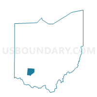
PRECINCT LIBERTY, Clinton County, Ohio
About
Outline

Summary
| Unique Area Identifier | 643672 |
| Name | PRECINCT LIBERTY |
| County | Clinton County |
| State | Ohio |
| Area (square miles) | 24.68 |
| Land Area (square miles) | 24.52 |
| Water Area (square miles) | 0.16 |
| % of Land Area | 99.36 |
| % of Water Area | 0.64 |
| Latitude of the Internal Point | 39.53808550 |
| Longtitude of the Internal Point | -83.81797310 |
Maps


Graphs
Select a template below for downloading or customizing gragh for PRECINCT LIBERTY, Clinton County, Ohio


Neighbors
Neighoring Voting District (by Name) Neighboring Voting District on the Map
- PRECINCT CAESARSCREEK 461, Greene County, OH
- PRECINCT CHESTER A, Clinton County, OH
- PRECINCT JEFFERSON TWP 401, Greene County, OH
- PRECINCT PORT WILLIAM, Clinton County, OH
- PRECINCT UNION NORTH A, Clinton County, OH
- PRECINCT UNION SOUTH, Clinton County, OH
- PRECINCT WILSON, Clinton County, OH
Top 10 Neighboring County Subdivision (by Population) Neighboring County Subdivision on the Map
- Union township, Clinton County, OH (3,085)
- Chester township, Clinton County, OH (1,967)
- Jefferson township, Greene County, OH (1,254)
- Caesarscreek township, Greene County, OH (1,137)
- Liberty township, Clinton County, OH (1,067)
- Wilson township, Clinton County, OH (505)
Top 10 Neighboring Place (by Population) Neighboring Place on the Map
Top 10 Neighboring Unified School District (by Population) Neighboring Unified School District on the Map
- Xenia Community City School District, OH (36,823)
- Wilmington City School District, OH (20,781)
- Clinton-Massie Local School District, OH (9,904)
- Greeneview Local School District, OH (8,148)